Run slope analysis from your QGIS project data.
Transfer contours, geological surfaces, boreholes, boundaries and slope model data from QGIS into TSLOPE, so you can move from mapped project data to 2D and 3D slope stability analysis without rebuilding everything first.
See the workflowQGIS data transfer in TSLOPE helps geotechnical engineers use the project data they already have. Instead of exporting, redrawing and reworking geometry, you can bring key QGIS data directly into TSLOPE and start building a practical slope stability model.
Use your existing QGIS project data.
TSLOPE is designed for practical geotechnical workflows where project data may already exist in QGIS.
Topography and contours
Bring in ground surface information and contours to help define slope geometry for analysis.
Geological surfaces
Use interpreted geological surfaces and material boundaries as part of your TSLOPE model setup.
Boreholes and investigation data
Transfer investigation data from the QGIS project environment into the TSLOPE modelling workflow.
Boundaries and slope surfaces
Use mapped boundaries and engineer-defined surfaces to support 2D and 3D limit equilibrium analysis.
Why it matters
Less rework before analysis.
Many slope stability workflows start with useful project information already sitting in GIS: contours, mapped geology, surfaces, boreholes, boundaries and site context.
The problem is that this data often has to be exported, simplified, redrawn or rebuilt before it can be used in slope stability software. TSLOPE reduces that gap by allowing QGIS project data to feed directly into the modelling workflow.
That makes it easier to test existing interpretations, compare 2D and 3D results, and update a model as the project data develops.
From QGIS project data to TSLOPE analysis.
Import your QGIS project data directly into TSLOPE for 2D and 3D limit equilibrium analysis.
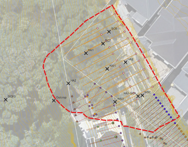
Example QGIS project defining slope surface geometry and investigation data.
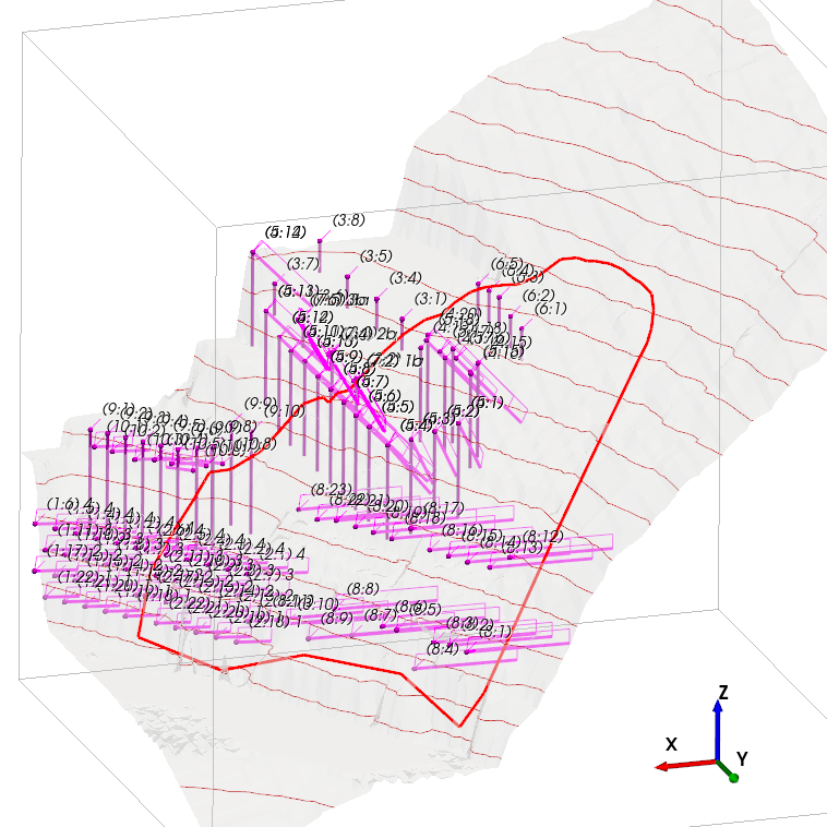
TSLOPE 3D model with ground contours, anchors and piles imported from QGIS.
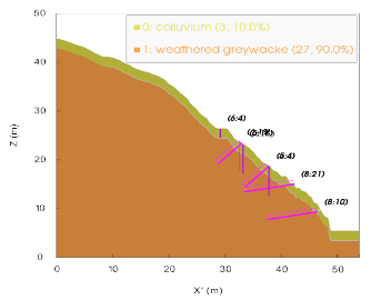
TSLOPE section view showing layered materials and slope reinforcement elements.
Where QGIS data transfer helps.
This workflow is useful when your slope model needs to stay connected to mapped site data and real project geometry.
Consulting projects
Move from GIS-based site data to slope stability analysis without rebuilding the model from scratch.
Mining slopes
Use mapped surfaces, contours and interpreted geology to support 3D slope stability assessment.
2D to 3D comparison
Start with known 2D sections, then extend the assessment into 3D using project geometry.
Model updates
Update slope models more easily when the underlying QGIS project information changes.
Why TSLOPE?
2D and 3D slope stability analysis, built for engineers.
TSLOPE is used for 2D and 3D slope stability analysis across practical geotechnical and mining problems, from open pit slopes and engineered batters to more complex surfaces controlled by geology, groundwater or reinforcement.
The engineer stays in control of the surface being analysed. TSLOPE does not force the model into a narrow predefined shape. You can work with engineer-defined basal surfaces, imported geometry and project-specific data.
TSLOPE includes a proprietary implementation of Spencer’s Method in 3D, supporting practical limit equilibrium analysis for complex slope problems.
Want to test your own QGIS data?
Start a free trial, import an existing project, and compare the results against your current workflow.

QGIS is an open-source Geographic Information System. QGIS and its logo are trademarks of the QGIS Development Team, used here to indicate software interoperability.